- Whereas in other areas at this time growth was brought about by migrants from Nottingham, driven out by conditions and prices in the town, the growth of New Sneinton was one and the same with the growth of the town. Houses built some distance away on John Musters' land at this time were of a better quality than those on Lord Newark (aka Lord Manvers)'s land which shared the poor quality of adjacent houses in the town.
 |
| Fig.1 |
According to Mellors, a few houses
were built at New Sneinton in 1804 (1); he elaborates no further
than this and acknowledges no source for his information. H Wild's map of 1820 shows a few buildings to the East of Carlton Road
and Sneinton Road, standing on John Musters' plot 13 (Fig.1). Also
shown is the road leading from Sneinton Road to Bond Street and West
Street.
 |
| Fig.2 |
Unfortunately the map does not
extend to cover any more than this, and it is difficult to know how
far the building extended at this time. Some indication is given by H
M Wood's map of 1825. (Fig.2) This shows that the grid of streets comprising
North Street, South Street, West Street, Bond Street and Haywood
Street has been laid out but is largely free of buildings, beyond the
few shown on Wild 's map and a couple of blocks on Bond
Street and North Street.There are no buildings at all in the
area on the enclosure map of 1796, and so if Mellors' 1804
houses do exist it is reasonable to suppose that they are among those
shown on Musters' plot 13. The pre-1820 houses were at that time a
good distance from the town, and would have been situated amongst
gardens and orchards on elevated ground and at this time, therefore,
perhaps deserved the title, 'handsome village'. But building in
earnest began around 1825, when the building line crept eastwards
past Water Lane and Carter Gate, to the River Beck and the Sneinton
Boundary.
 |
Fig. 3 H M Wood's Map 1825
Showing the 1820 building
line in red |
H M Wood's map of 1825 shows
the grid of streets on Musters' plot 13, mentioned above, and it also
shows that Lord Manvers' plot between the Beck and Sneinton Road had
been prepared for building. A couple of houses had been already
erected on plots at the corner of Manvers Street and Old Glasshouse
Street (now Southwell Road), and at the corner of Manvers Street as
far as the Beck. Pierrepont Street had been laid down to join Water
Lane and Sneinton Road, passing to the South of Earl Street. Manvers
Street had been laid between its junction with Glasshouse Street and
the intersection with Pierrepont Street. Pomfret Street had been
extended across the Beck and the Sneinton boundary as far as Manvers
Street, and Eyre Street continued its route to Sneinton Road.
In 1820 the block between Old
Glasshouse Lane and Pennyfoot Stile appears to to have had building
in progress upon it, and similarly the block between Gedling Street
and Old Glasshouse Lane. By 1825, in the former block, houses had
been erected along the full length of Pomfret Street, white Street,
Earl Street and Stanhope Street, and were crowding up against the
Sneinton boundary along the West side of the Beck. In the latter
block, Nelson Street, Pipe Street, Brougham Street, Sheridan Street
and Finch Street had been completed. Building had progressed as far
as it could to the Northeast in this block, for beyond the row of
back-to-backs on the North-eastern side of Finch Street lay the Clay
Field. To the Southeast of the block lay Earl Manvers' close.
Earl Manvers began to dispose of
this close of land in 1823 and early 1824. The Nottingham Journal
carries advertisements offering for sale building land in lots of 200
to 1000 yards.
'The whole will be laid out with spacious streets,
commanding an immediate communication from Fisher Gate, to the upper
part of New Sneinton, and affording most desirable sites for private
dwellings, factories or malting offices' (2)
The land was sold,
according to Mellors (who gives 'papers in the hands of Mr W F
Grundy' as his source) subject to conditions that the houses built in
Sneinton should be not less than three storeys high above the surface
of the ground and must have 'front bricks and sash windows'. (3)
The streets were set out as being 24, 27 or 30 feet wide (4). This
land was of rather poor quality, being low and difficult to drain. It
fetched 11s6d to 24s9d per square yard (5) – not as high as that
inside the town (36s at its highest rate) but considering distance
from the town and the poor quality of the land, not a bad price.
Mellors regrets that 'The care
exercised in [the conditions upon building] was not accompanied by
any forbidding cellar kitchens or back-to-back houses or narrow
entries or insanitary arrangements (6). And it is interesting to
compare the housing on Musters' plot 13 with that on Manvers' as it
stood in 1828-9. Chapman rightly observes that the proportion
of back-to-back houses in the area was lower than that in the town:
what back-to-back housing does exist, exists largely in Manvers'
plot. Byron Street and Camden Street show that Musters' land had no
covenant prohibiting back-to-backs (unlikely anyway at this time).
Musters' land is of a better quality than Manvers', being elevated,
surrounded by open country and isolated from the lower part of the
town. So it seems reasonable that a fair standard of building would
be erected in order to attract the higher rents paid by those who
could afford to be more selective in their choice of area.
Manvers' plot, on the other hand, is different from the lower part of
the town only insofar as it was under different ownership, and lay
across the trickle of water known as The Beck, and across the Sneinton
boundary. Thus the building between Sneinton Road and The Beck, and
in particular that between Manvers Street and The Beck, can be
regarded in everything but name as an extension of Nottingham's lower
congested area.
The first buildings to appear on
Manvers' close were at the junction of Manvers Street and Southwell
Road, to the West of of Manvers Street and between Manvers Street and
The Beck. These were built by Joseph Nall, a local builder, who
bought the land in 1824. They are shown on Wood's map of 1825 (Fig.3). The
plot measured 40ft in length and 20ft wide at its narrowest end. Nall
managed to cram four houses into this space (7, Fig.4). These were
'through' houses, surrounding a tiny courtyard whose Southwest facing
side was blocked off by the building across The Beck. (Which as yet
was not culverted.)
 |
| Fig.4 |
Wood's
map of 1825 needs to be handled with care with regard to Sneinton. It
seems that the map must have been surveyed fairly early in the year
and, because of the building activity which took place in Sneinton
during that year, omits much that can claim to have been there in
1825. By the end of 1825, the whole of the land bounded by Southwell
Road, The Beck, Pomfret Street and Manvers
Street had been built upon (8, Fig. 4), although this is not shown to be
the case by the map. The block measured 216ft x 50ft x 220ft x 20ft, and contained thirty houses: eighteen of them paired into
back-to-backs, facing upon Manvers Street and Pomfret Street on the
outside and Beck Yard on the inside. These back-to-backs were a
continuation of those already built in White Street and Pomfret
Street. They were of the standard three-storey design, arranged in
terraces backing onto each other so that they had only one wall not
shared. This style, says Chapman, was widely adopted in Nottingham
between c1784 and 1830 (9).
 |
| Fig.5 |
They were coming onto the market by
mid-1825:
'To be sold by auction … all those
17 freehold dwelling houses (newly erected and substantially built)
in Pomfret Street and White Street in the town of Nottingham …
[producing] an annual rent of £166 per annum: and also, all those 14
freehold dwelling houses adjoining to the last mentioned messuages
and situated in the parish of Sneinton … producing an annual clear
rental of £145 …' (10).
Press advertisements also show that
property was coming onto the market in the Pierrepont Street and
Kingston Street areas, which are not shown to be built up by Wood's
map of 1825:
'Six newly erected dwelling houses
situated in Kingston court, near Pennyfoot Stile, five storeys high,
all in the hands of good tenants; are very substantially built,
well-timbered, and have a pump of good water for the use of the
estate. Each house has a low kitchen, house place [living room?]
chamber [bedroom], workshop and attic.' (11).
This seems to be a good example of
estate agent double talk: no buildings in the area could have been
described as being five storeys high. Ground floor, bedroom, workshop
and attic or 'cockloft' was standard. The matter seems to be resolved
by the vendor's inclusion of the 'low kitchen' into the height above
ground of the dwelling. The low kitchen would have been a basement or
half-basement kitchen such as those which irritated Mellors. The
workshops were built 'for the accommodation of twist machines.'
As with Manvers' plot, Wood's map is
also misleading about Musters' land on the other side of the road.
Press advertising shows that at least one large block in the South Street
area of plot 13 was tenanted at the beginning of 1826. The
advertising bears out the suggestion made above that there was
a difference of standard between Manvers' plot adjacent to the
Nottingham boundary and Musters' plot, higher and having one side
looking over the Clay Field. In February 1826 a block fronting onto
South Street containing houses, a brewery and a malthouse was offered
for sale, ready tenanted (12). The houses were described as being '
… commodious … with gardens … bake-houses, front shops, factory
adjacent thereto, and outhouses'.
 |
Fig.6 1881 OS 25 inch
___ Sneinton - Nottingham Boundary |
Examination
of the 1881 25 inch OS map of the area (Fig.6) and of Staveley and
Wood's, shows that the portion of the Water Lane – Pierrepont
Street – Sneinton Road – Glasshouse Street block which lies in
Nottingham and outside Manvers' plot is comprised totally of
back-to-backs very closely packed. That part of Manvers' plot lying
between Manvers Street and The Beck, and which has already been
discussed, is composed of two thirds back-to-backs, while the
'throughs' are very closely packed. The story is similar with that
part of Manvers' plot which lies between Manvers Street and Sneinton
Road. There are 'throughs' with adequate yard space at the junction
of Manvers Street and Southwell Road (then Old Glasshouse Street),
and also a row of 'throughs' with rather less yard space along
Sneinton Road. Behind these facades lie the tiny courts and
back-to-backs. Thus Manvers' plot seems to have been much the same as
the congested lower town, with the addition of a few more desirable
residences along the new, wide, roads. |
Fig.3 1881 OS 25 inch map
showing part of Musters' plot 13 |
Examination of the same maps shows
that Musters' plot contained only through houses at this time, all
with adequate yard space, and, if the advertisement is right, some
with gardens. These were bigger than the back-to-back type, and, with
windows running along the sides of their workshops, could accommodate
more lace machines. Nearly all of these survived until 1958, when
they were removed during slum clearance (See Photos 1 - 4).
The vendors' descriptions of property
on Musters' plot are generally more fulsome than their descriptions
of property on Manvers' – going into details of scenery and
elevation, employing adjectives such as 'commodious' and 'spacious',
and are 'suitable for retirement' (13). They are unlikely to be
subject to 'annoyance from other erections' (14). 'Substantial' and
'well built' is about as far as anyone goes in describing property on
Manvers' side.
How much was paid in rent by those
living in the area is difficult to discover, as is the case,
apparently, with Nottingham as a whole at the time. Chapman has
compiled a table, from what evidence exists, of rents paid for
working class housing in the city. (Table 1).
Table
1
|
Rents
charged for working class houses in Nottingham 1825-50
|
|
|
2
Storey
|
3
Storey
|
Houses
of a 'Better Sort'
|
|
1825
|
-
|
2s6d
|
-
|
|
1829
|
1s6d
|
-
|
-
|
|
1833
|
2s3d
|
-
|
3s6d
|
|
1845
|
1s6d
|
2s2d
|
3s0d
|
|
1850
|
1s9d
|
2s2d
|
-
|
|
Source:
Nottingham Review 30 September 1825, 17 April1829, 28
February1845, 25 January 1850; Nottingham Journal 8
November 1833
|
The only evidence of the rents paid
in Sneinton is that given by the advertisements for investment
property, and most of these are only useful with regard to property
on Manvers' plot. What evidence there is suggests that rents for
back-to-back houses were around the 4s0d mark – a very high sum
indeed, compared with Chapman's average. They all come in the three
storey category which Chapman prices at 2s6d. There may be some
explanation for this high figure (which is based on flimsy evidence
anyway) however. This was the time when the boom in house building
was at its height, and when the lace trade was most prosperous. All
the new property coming on the market was ready-tenanted, suggesting
no shortage of demand. The district was most definitely predominantly
occupied by lace makers (see below table 2), who at this time could afford high
rents and were a causal factor in the housing boom. Further,
Chapman's figure is an average, and it could be a misleading average,
for it may consist of two widely different basic elements. As he
himself says, the highly prosperous lace-makers of the 'twenties
occupied different properties to the depressed frame-knitters:
'Inevitably this divergence of
fortune was reflected in housing conditions. … By the early 1830s
the two social groups lived in houses of different sizes and
qualities, but also in different parts of the town … the lace hands
lived and worked in the upper storeys of substantial houses … in
the approaches and the back streets … and the better houses of the
lower town … numbers of them moved out into the new industrial
villages. The framework knitters lived in the more obscure courts and
alleys. Descriptions obviously refer to … back-to-backs built in the first stages of industrialisation'. (15)
The difference in rent paid by these
depressed knitters and the rents paid by lace hands for newer,
better, property could account for an average which approaches neither.
As to the basic stimulus for the
growth of New Sneinton in the 1820s it can be safely said that it was
the boom in the lace trade. On the sheets of signatures to the
agreement to limitation of hours organised by Felkin in 1829, there
are signatures belonging to 87 owners who give their address as
Sneinton.
According to White's Directory of
1832, the number of new houses built during the decade was 'upward of
a hundred' (16). The appearance of 87 machine owners and of 100
houses simultaneously can only mean that they were occupying the new
houses – all of which (except for the small number of larger middle
class houses) had second floor workshops.
The signatures are of no help in
placing the owners: addresses are merely given as 'Sneinton', 'New
Sneinton', or 'Old Sneinton'. White's Directory is of some little
help however, giving addresses (in 1832) of 56 bobbin net makers
(17). The majority - 37 - of these have their addresses on Musters'
plot 13 (Table 2). Only 5 are definitely on Manvers' land.
Table 2
|
Distribution
of Bobbin-net makers at New Sneinton as listed in White's
Directory 1832
|
|
Windmill
Hill
|
11
|
These
are on Musters' Plot 13.
|
|
North
Street
|
7
|
|
Bond
Street
|
6
|
|
South
Street
|
9
|
|
West
Street
|
2
|
|
Haywood
Street
|
2
|
|
Pierrepont
St
|
4
|
These
are on Manvers' land.
|
|
Manvers
Street
|
1
|
|
Sneinton
Road
|
8
|
These
could be on either Musters' or Manvers' land depending on which
side of the road they are.
|
|
Carlton
Road
|
6
|
Even considering White's Directory
and the hours agreement together, however, there is little in the way
of hard conclusions to be had. Lace machine owners are not
necessarily bobbin net makers, and frequently bobbin net machine
operators rented their machines or operated them for a middleman.
What information can be had?
Felkin's list (18) tells us that the 87 owners had between them 152
machines. One owner had eight, one six and a number, four. 45 had
one, and there was a fair proportion of owners of two or three. There
was no sharing of machines.
It is reasonable to suppose that
those owning one or two machines operated them themselves, possibly
with the help of employed hands, in their own homes. This may well be
the case with owners of three machines (19). The owners of four or
more machines would certainly have had machines and work farmed out
to other operators in other houses, and there is nothing to rule out
the possibility that they did not operate them at all themselves –
perhaps even living in the larger middle class houses near the old
village.
If the criterion of ownership of two
machines or fewer is applied in classifying owners who operated their
own machines in their own homes, this makes, according to Felkin's
list, 73 owner-operators. White's list is obviously incomplete, which
is to be expected of a county directory anyway, and which fact is
shown up by comparison of the population figures and the number
included in the occupations guide. Some sort of selectivity must have
taken place. Bearing in mind that the practice of farming out
machines and work was common enough, and also bearing in mind that
the owner-operator would be a person of greater substance than an
employed operator, perhaps it can be said that this selectivity
operated in favour of those operators who owned their own machines.
These would be the sort of people solicited for inclusion – or who
would apply for inclusion. From this and from the fact that the
greatest number of bobbin net makers in White's Directory occupy
houses on Musters' plot 13, a tentative conclusion may perhaps be
drawn. Assuming White's Directory to be selective in favour of the
more prosperous lace-machine operators, there are additional grounds
for believing that the area which grew up on Musters' plot was
'better' than than that which grew up across the road on Manvers'
plot. The suggestions are that there were larger, more spacious
houses, fewer back-to-backs and, if the reasoning and evidence in the
previous paragraph are sound, a higher number of people with capital
of their own, i.e. bobbin-net machines, on Plot 13 than on Manvers'
plot.
***
Sneinton, a small village a mile or
so to the East of Nottingham, took its first major step on the road
to becoming an urban quarter in the 1820s. In the Nottingham area was
concentrated an industry organised as a domestic outwork system. The
industrial revolution gave a tremendous boost to this industry which,
as a making-up industry, was able to profit from the abundance of
cheap factory-produced yarn. A degree of prosperity in a domestic
industry gave rise to a building boom of considerable proportions in
the middle of the decade. A building boom in a city which could not
expand outwards on most of its perimeter caused a high degree of
congestion within the city. As pressure built up within the
Nottingham boundary, the building line burst through into Sneinton,
adjacent to Nottingham, and unencumbered by old open field
restrictions.
Basically then, the first phase of
Sneinton's growth differed from the first phases, occurring at the
same time, in the growth of other areas which now form quarters of
Nottingham, such as Hyson Green, Radford and Carrington. Whereas in
these areas growth was brought about by migrants from Nottingham,
driven out by conditions and prices in the town, the growth of New
Sneinton at this time was was one and the same with the growth of the
town. In quite a literal sense, Nottingham spread into Sneinton.
Having said this, there are some
small grounds for considering the possibility that Sneinton Road
formed a sort of demarcation line with an area more akin to the
'handsome villages' on the eastern side, built on Musters' plot, and
a continuation of Nottingham's congested lower area on its western
side, on Manvers' land.
This study is by no means an
exhaustive study of Sneinton's first growth phase. A long and
detailed study of all the deeds to the area, which are becoming
available as demolition progresses, is a priority. Perhaps when this
is done, the next phase in the history of Sneinton, with the hard times in the lace industry of the late 'thirties and the 'forties,
and with the degeneration of the area into a slum, can be considered.
***
Map Accompanying the Sneinton Enclosure Act 1792
(Note: Lord Newark became Earl Manvers in 1806)
Development within Enclosure plots by 1829:
12, 13, 14 - John Musters,
15, N - Lord Newark (i.e. Earl Manvers)
%20-%20Boundary%20-%20Plots%2012%2013%2013%2014%2015%20N.jpg) |
| Staveley and Wood's Map, surveyed 1829, published 1831 |
Map accompanying a flyer for a land auction, August 1835
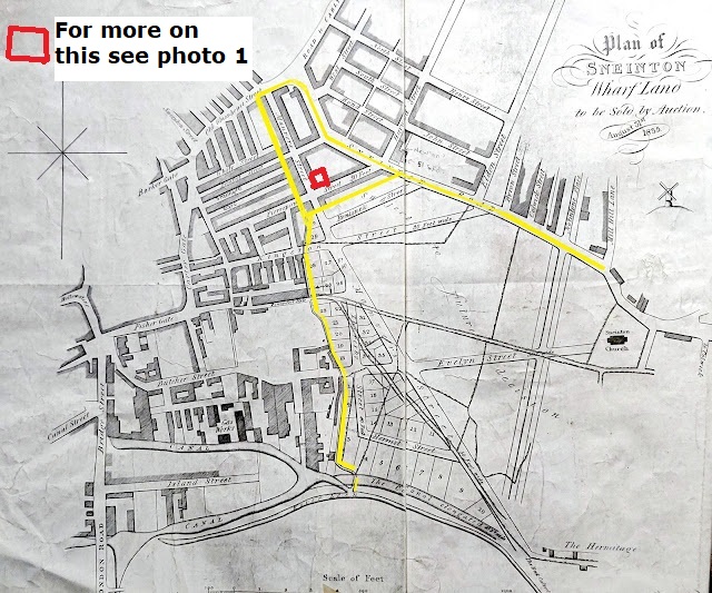
This plan shows Nottingham's buildings crowding up against Sneinton's boundary at the River Beck; across on the other side, Lord Newark is selling his next trenche of building land. It is a fascinating glimpse into events as they happen - lanes, footways and hedges are still there, streets are conjectural and the east side of Manvers Street is 'Subject to future decision'. Surveyors have been out measuring and draughtsmen have divided up the fields into numbered plots ready for the builders to come and bid for them. See photo 1 for an example of what was built on it.
(Note: this map did not appear in the original dissertation as it was discovered some years after it was submitted.)
 |
| Photo 1: Manvers Square, pictured in 1931, a typical enclosed court with tunnel entrance, on Manvers' land, shown as already built in the flyer of 1835 (above) |
The map below shows Manvers Square in its location at the corner of Pierrepont Street and Manvers Street.
 |
Photo 2: Manvers Square as shown on the OS large scale town plan of 1882.
|
 |
Photo 3: Houses on Bond Street, Musters' plot 13, prior to demolition 1950s
|
 |
Photo 4: Houses on Musters' land at the junction of North St and Carlton Rd in the 1950s showing large upper storey workshop windows
|
 |
| Photo 5 |
Photo 5 shows the corner of Manvers Street and Southwell Road - the site of Joseph Nall's houses.
.
Wood's 'Gas Bill' map of 1841, accompanying an act of parliament for supplying gas to the areas beyond the town, shows development progressing on Manvers' land. Also, there are houses at Sneinton Elements at the end of Windmill Lane, and at the junction of Carlton Road and Alfred Street - the Clarence Street area. The map also demonstrates the restricting effect of the unenclosed commons - soon to be addressed by an enclosure act in 1845.
 |
| H M Wood's 'Gas Bill' Map 1841 |
End of the Dissertation
But for more of Sneinton and me scroll down and select 'Newer post' or the Left arrow.
Notes
1/ op.cit p.10
2/ Nottingham Journal 27th December 1823 and subsequent issues to 31st January 1824, also 5th June 1824
3/ibid, and deeds to property at At Manvers St. Central Library Archives
4/ Ibid5/ Ibid
6/ Ibid/
7/ Deeds to the property at City Library Archives M21,385 to M21,4145;
8/ The above deeds and also deeds to 6-26 Manvers St, and Beck Yard 1-5 inc.; Manvers St 28-34 (even); M21,436-21,503; M21,467-M21,485
9/ op.cit p.140 (Revision)
10/ Nottingham Journal 28th May 1825
11/ op.cit 8th October 1825
12/ Nottingham Journal February 2 1826
13/ Nottingham Journal 20th November 1824
14/ op.cit 22 April 1826
15/ op.cit p.151 (revision)
16/ p687
17/ p689
18/ Which, in view of the fact that it so narrowly missed the 7/8 majority can be regarded as being almost a complete list. The better houses were sometimes advertised as having room for 3 machines, e.g. Nottingham Journal 8th October 1825
19/ The better houses were sometimes advertised as having room for 3 machines, e.g. Nottingham Journal 8th October 1825
Maps:
H Wild, 1820
H M Wood, 1825
Wood's Gas Bill Map
Staveley and Wood, surveyed 1829, published 1831 Staveley and Wood's Map of Nottingham, surveyed 1828-9, published 1831: a high resolution download is available at
OS 25 inches to 1 mile, OS Large Scale Town Plans and many others can be seen at the National Library of Scotland's brilliant interactive collection of historic maps at: https://maps.nls.uk/
Photos:


%20-%20Boundary%20-%20Plots%2012%2013%2013%2014%2015%20N.jpg)


